


Entrusted by the client, our company conducts a geophysical survey on a solid waste dump. The main landfill of this solid waste dump is slag, which has been stacked for more than 20 years. It covers an area of about 11,000 square meters and is about 40m high. In this survey, the high-density resistivity method and drilling were selected as the main geophysical survey methods for detecting pollutants in the survey area, and the depth and scope of the solid waste landfill in the survey area were ascertained, which will provide a basis for the later restoration and supervision of the solid waste landfill site. Other works provide geophysical basis.
The main purpose of this time is as follows:
● Collect existing geological data in the survey area, understand the distribution and boundaries of solid waste landfill in the survey area;
● Ascertain the distribution range, boundary and depth of hidden dangers of solid waste landfill in the investigation area, and provide reliable information for later construction.
Equipment
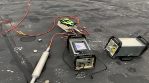
In this work, the GD-20 high-density resistivity system was used for high-density resistivity measurement, and the information of the measuring points was collected by RTK.
The GD-20 high-density resistivity system supports conventional electrical sounding, and can also use two-dimensional and three-dimensional arrays for cross-sectional testing, which can be used for self-electricity, apparent resistivity and induced electrical testing.
GD-20 high density resistivity system diagram
Program
Figure 2 Layout of ERT survey lines in the survey area
Figure 3 On-site working photos
A total of 6 ERT survey lines were laid out for this survey. The east-west survey lines are all distributed from west to east, and the north-south survey lines are all distributed from south to north. Each measuring line covers the surface layer of the HDPE geomembrane area and continues to extend to both sides. The surrounding vegetation in the area not covered by the HDPE geomembrane is relatively dense due to years of abandonment, the reeds are dense, and the elevation drop of the slope area is relatively large. The high-density electrical method has the advantages of high resolution, high accuracy, and deep detection depth. It is suitable for detecting various stratigraphic distributions and hydro-geological distributions. The processed electrical stratigraphic map can fully present the characteristics of the underground environment.
Figure 4 ERT5, ERT6 resistivity profile results
In order to observe the distribution of buried objects in the investigation area more intuitively, the resistivity results of the high-density resistivity method survey line are formed into a grid map to obtain a comprehensive map of high-density resistivity distribution in the field, which is displayed from different angles. As shown below.
Figure 5 ERT grid result map
The vegetation coverage area on the north and west sides of the survey area is larger, and the vegetation is dense and extends longer. The southeast side is the slope area of the solid waste storage yard. The overall ground resistance anomaly display area is consistent with the location of the on-site drilling results and the information obtained from preliminary visits. The on-site drilling results reveal that the solid waste landfill depth is about 0 to 19 meters deep.


Industry-leading geophysical equipments and service provider supplier


