


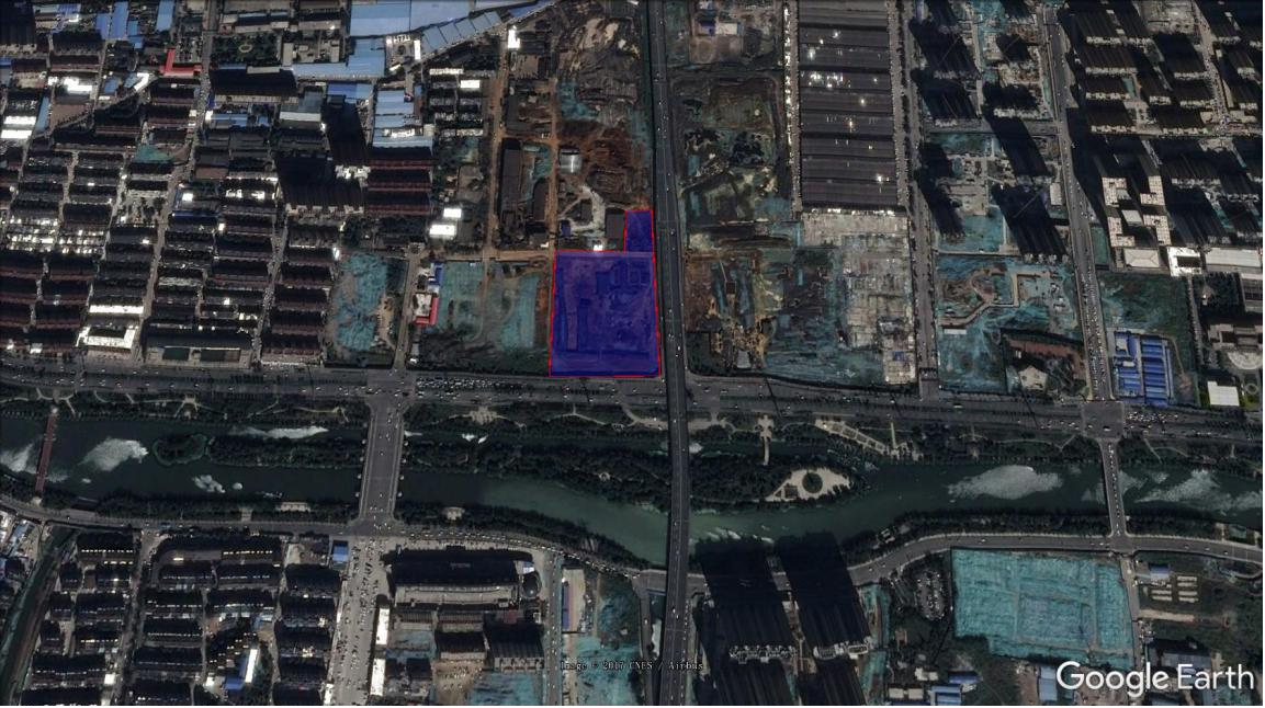
The test area is located in the old factory building of Yuxing Chemical Factor which is a large-scale heavy metal soil pollution site. The geophysical detection area is about 352,000 square meters. The site range is shown in Figure 1 below.
The high-density resistivity method and the induction electromagnetic method will be used to measure the pollution distribution of large-scale heavy metal soil pollution sites with geophysical technology. At the same time, combined with the existing excavation drilling and XRF screening data, the local electrical characteristics and depth variation trends of soil pollution in the model field can be verified, and the underground pollution and stratigraphic conditions can be depicted with specific images of the geophysical exploration results, so as to accurately assess the depth of soil pollutio and high-concentration heavy metal soil pollution areas and provide reliable information for later construction.
High density ground resistance method
This geophysical exploration is to detect the distribution of soil pollution. The high-density electrical method is used in the field work design, which can achieve a higher density in the horizontal and vertical directions and obtain the parameters of the resistivity of the rock and soil layers of the site within a certain depth range, to detect the spatial distribution of various rocks and soil layers, etc., meet the requirements of the purpose.
The resistivity method is based on the difference of medium resistivity, uses a certain electrode device to supply a stable current to the ground, observes the power supply current intensity and the potential difference between the measuring electrodes, then calculates and studies the apparent resistivity, and infers the waste buried in the ground or distributions that may contaminate the soil.

Schematic diagram of the principle of resistivity method
The high-density electrical method is the most widely used electrical survey developed from the resistivity method. Its basic theory is exactly the same as that of the traditional resistivity method. When measuring on-site, all the electrodes only need to be arranged on the measuring points at a certain interval, and the mainframe and switch relay will automatically control the changes of the transmitting electrode and the receiving electrode. The high-density electrical measurement system adopts advanced automatic control theory and large-scale integrated circuits, and uses a large number of electrodes, and the electrodes can be freely combined, so that more geoelectric information can be extracted, enables electrical surveying to use multiple coverage measurements like seismic surveying.

Schematic diagram of high density resistivity method
Compared with troditional electrical methods, high-density electrical methods have the following advantages:
①The electrode layout is completed at one time, which reduces the interference caused by the electrode setting and the measurement error caused by it;
②It can effectively carry out scanning measurement of various electrode arrangements, so that rich geological information about the structural characteristics of the geoelectric cross-section can be obtained;
③The field data collection is automated or semi-automated, which not only has a fast collection speed, but also avoids errors due to manual operations;
④On-site real-time processing and offline processing of data can be realized, which greatly improves the intelligence of the electrical method;
⑤ It can realize multi-parameter measurement, observe resistivity, polarizability and natural potential at the same time, obtain abundant underground geoelectric parameters, and describe the underground structure from different electrical properties. Therefore, the high-density resistivity method is an exploration method with low cost, high efficiency, rich information, convenient interpretation and significantly improved exploration ability.
Electric method can be applied to the investigation of various types of sites, and can also obtain very rich results. When conducting a site survey, the abnormal resistivity should be determined by instruments first, and then confirm the standard resistivity value of the polluted abnormal site, select the standard electrical strata area where closest to the survey area and establish the standard electrical stratigraphic profile.
Induction electromagnetic method
The induction electromagnetic method is mainly to obtain the characteristics of soil conductivity in a large range, and to delineate the distribution of the large conductivity of the site, which has a good effect on the delineation of the scope of heavy metal pollution.
Induction electromagnetic method, referred to as EM method, is to use the principle of electromagnetic induction to detect the formation. During the survey, the transmission coil is connected to a variable frequency alternating current (usually in the audio frequency range) on the surface to generate a primary magnetic field that changes with time. A time-varying eddy current is generated in the interior, and its current density depends on the resistivity of each layer. If the underground medium is not uniform, induced secondary magnetic fields will be generated on the overburden, surrounding rock and local conductors. The secondary magnetic field intensity is recorded by a receiving coil on the surface, which can be used to understand the electrical conductivity distribution of the underground stratum, and then infer the electrical structure and abnormal body of the stratum.

Schematic diagram of electromagnetic detection principle
Induction electromagnetic method results
Induction electromagnetic method is suitable for local investigation and evaluation of large-scale waste burial locations and heavy metal contaminated soils, and is suitable for rapid and comprehensive surveys. At the same time, combined with high-density resistivity method or drilling sampling analysis, the actual vertical depth and characteristics of buried objects can be found out.
The test site uses a multi-frequency induction electromagnetic detector to evaluate the effectiveness and feasibility of soil pollution analysis. The detector can detect stratum conductivity data at a depth of 0 to 10 meters underground, and the detection depth is sufficient to cope with most waste burials and soil pollution site survey, and can provide multi-frequency multi-depth layer imagery.
According to the detection results, the color scale in the result map represents high conductivity (low resistivity) in red, while the blue-violet series belongs to the low conductivity range (high resistivity). In the comprehensive conductivity distribution of (a) Area A , the overall conductivity is relatively high, and the evaluation of high conductivity strata with a value greater than 300mS/m covers the entire survey area, only the local block on the northwest side and the east side wall are low conductivity areas, and the survey area is within 0-10 meters. There is a distribution of heavy metal pollution in the soil, showing a red color level greater than 400mS/m, which is presumed to be a deeper heavy metal contaminated soil area; in (b) B area comprehensive conductivity distribution: The stratum with a high conductivity greater than 300mS/m is presumed to be a heavy metal contaminated soil area. There are six pollution blocks from A to F. The survey area has a distribution of heavy metal soil pollution within 0 to 10 meters, showing a red color level greater than 400 mS/m. , presumed to be a deeper heavy metal-contaminated soil area.

Area A Results Map

Results map of area B
Results analysis of high density earth resistance method
The high-density resistivity method has the advantages of high resolution, high accuracy and deep detection depth. It is suitable for detecting various soil and groundwater pollution problems and hydrogeological distribution. The processed electrical stratigraphic map can fully present the characteristics of the underground environment.
Based on the detection results of 13 high-density resistivity survey lines, It shows that the resistivity of normal original soil is significantly different from that of contaminated soil. The average depth of heavy metal contaminated soil is about 0 to 18 meters, and the depth of heavy metal contaminated soil can be depicted in the result map. The resistivity range of the analyzed polluted soil is about 2 Ohm-m. The high-density resistivity method has the ability to quickly identify the depth and scope of pollution, effectively and accurately identify the depth and scope of polluted soil, and provide reference information for subsequent soil remediation.

Figure 2 Background results of the ground resistance method

Figure 3 Results of the ground resistance method ERT-1

Figure 4 Results of ERT-2 by ground resistance method

Figure 5 Results of ERT-3 by ground resistance method

Figure 6 Results of the ground resistance method ERT-4

Figure 7 Results of ERT-5 by ground resistance method

Figure 8 Results of the ground resistance method ERT-6

Figure 9 Results of the ground resistance method ERT-7

Figure 10 Results of ERT-8 by ground resistance method

Figure 11 Results of ERT-9 by ground resistance method

Figure 12 Results of the ground resistance method ERT-10
Figure 12 Results of the ground resistance method ERT-10

Figure 13 Results of ERT-11 by ground resistance method

Figure 14 Results of ERT-12 by ground resistance method
(1) Yuxing site has a large-scale heavy metal soil pollution problem, and electrical geophysical exploration technology is applicable.
(2) The heavy metal-contaminated soil at the Yuxing site has obvious characteristics of low resistivity, and the soil with high concentration of heavy metals has the characteristics of high conductivity. The survey results show that the whole site has heavy metal pollution problems, and the site pollution depth is about 0-18 meters. .
(3) Multi-frequency induction electromagnetic method technology has the ability to quickly identify the distribution of heavy metal soil pollution. The high concentration range can be confirmed by magnetic susceptibility analysis. The daily survey efficiency is about 20,000 to 30,000 square meters, helping to clarify the high-concentration contaminated soil area. , to provide reference information for subsequent soil remediation.
(4) High-density resistivity method technology has the ability to quickly identify the depth and scope of pollution. The daily survey efficiency is about 100-500 meters. Faced with sites with large changes in the distribution of pollution depth, it can accurately and effectively identify contaminated soil depthand scope, providing reference information for subsequent soil remediation.
(5) For high-concentration soil pollution areas, focus on arranging survey lines to understand the distribution area and depth of pollution groups as a whole.
(6) Geophysical exploration technology is a good tool for soil and groundwater pollution investigation, which can expand the investigation area and depth, finely evaluate the underground environment, and help improve the overall efficiency of pollution investigation operations.


Industry-leading geophysical equipment and service provider supplier


