

1)The traditional survey method, drilling sampling, impossible in the operation of the Sinopec plant, for the coverage is not strong, it is difficult to fully understand, and the drilling or penetration detection .It will destroy the distribution and enrichment structure of pollutants in the ground, which may cause the pollutants to migrate to a deeper place, resulting in secondary pollution and difficult to use survey data to analyze the migration law of contaminated sites.
2)The geophysical method is based on the difference in physical and chemical properties between the pollutant and the surrounding medium. With a certain device and a special instrument, the distribution of the physical field is measured, and the distribution and migration of the pollutant are inferred. The method has the advantages of large depth of sounding, high precision, fast, multi-sample, continuous information and in-situ losslessness. It can not only qualitatively delineate the contaminated area of the site, but also divide the stratum structure of the site and judge the groundwater depth and flow direction of the site. .
3)The main purpose of the environmental geophysical method is to increase the on-site information. The information from the original point is extended to the surface and the body. It is not a substitute for the traditional detection technology, and it is complementary to the traditional drilling sampling.
Purpose of the survey
The main purpose of this survey is to detect whether the soil in the work area is contaminated and the distribution of pollution.
Survey Method
Electrical Resistivity Tomography and Ground Penetrating Radar (GPR). Ground penetrating radar mainly excludes underground obstacles and pipelines.
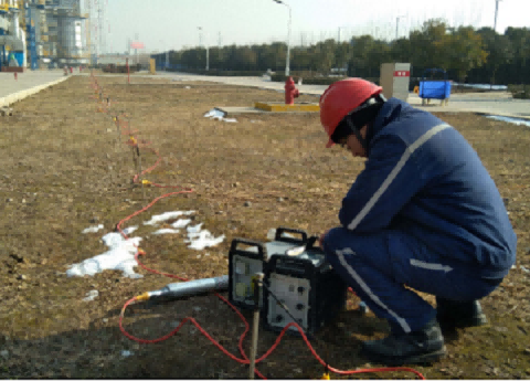
Equipment
GD-20 multi-channel workstations , GPR instruments and RTK.
Cable configuration
Reasonable layout of survey lines is an important factor in obtaining high-quality data. This time, combined with high-density resistivity method and ground penetrating radar method, geophysical exploration technology is used to detect large areas of suspected soil pollution distribution, and a total of high-density electrical method is deployed. The effective length of 54 lines is 8772m, which can provide complete underground information for the owner for the basic conditions of the scope, depth, abnormal signal area, pipeline orientation and buried depth of the work area.


Electrical resistivity tomography
The resistivity method is a geophysical method based on the difference in dielectric resistivity. The detection principle of the DC resistance method is to establish an artificial electric field by using a direct current to pass a pair of current poles A and B into the ground. By the difference in conductivity between the interlayer media, another potential pair M, N can be used to measure the potential difference between the electric field between M and N, thereby obtaining the apparent resistivity of the formation and estimating the underground formation. Conductivity distribution.

Ground penetrating radar
When measuring high-frequency electromagnetic wave reception, a continuously digitized waveform is used to describe the shape of the different two-dimensional reflection profile of the underground material due to the difference in dielectric constant.


North Area
1)The tank area in the area is presumed to be the main pollution potential area.
2)The main pollution depth is distributed between 2-6 meters and 12-16 meters.

South Area
1)The main pollution in the southern area is below 10 meters, which is distributed in the range of 10-16 meters. There is no obvious pollution above 10 meters.
2)The pollution potential area is mainly located in the sewage treatment tank
The plane distribution range of the abnormal value of the measurement area is determined by the inductive electromagnetic method, and the distribution range of the abnormal value of the measurement area in the vertical direction is determined by the high-density resistivity method. The two methods are closely matched to obtain the geological body in the space of the measurement area. Characteristic parameter
The traditional way of investigating is to estimate the possible distribution through limited borehole sampling, and to estimate the extent and depth of the pollution distribution through the correlation of the results between the points; the geophysical prospecting is non-destructive. The method of measuring the landfill and stratum structure under the ground, in addition to the characteristics of no drilling, can also obtain continuous profile data through a wide range of measurements.
Geophysical methods investigate contaminated sites, no holes are exposed, prevent further spread of pollution, environmental protection, and no secondary pollution.


Industry-leading geophysical equipment and service provider supplier


