


Purpose of the survey
l Exploring the distribution and depth of the oil leakage
l Find out the location of the oil leakag
Survey Method
Adopt GPR and electrical resistivity (Tomography) for geophysical exploration.(As for the investigation of the distribution of the underground oil like LNAP L pollution,the traditional method is to predict the possible distribution through limited borehole sampling or MIP, and to estimate the range and depth of the p ollution distribution through the correlation of results between points.But in this way,will face the problem of complicated site filling and insufficent spot samp ling.Geophysical exploration is the measurement of underground landfills and formations in a non-destructive manne. In addition to non-required boreholes, b ut also can be obtained continuous profile data through a large range of measurements.Therefore,it is recommended to use the GPR and ERT in this investigati on By surveying the difference underground material's resistivity distribution and dielectric constant,we can understand the range and depth of oil pollution dis tributionan to make up for the shortcomings of the traditional investigation, so as to complement each other
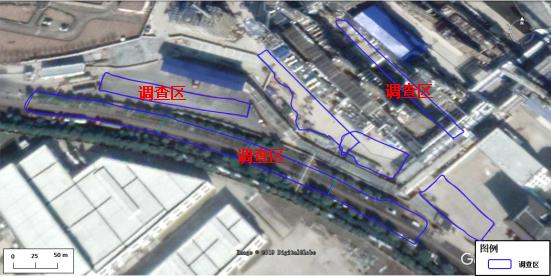
The site is divided into several small grid totally ab out 9000 square meters and investigated by GPR.In the treelawn measured 4 ERT lines in 1 meter spaci ng ,each measuring line is 100 meters totally 400 m eters.

GDR


Schematic diagram of reflection detection Radar record diagram
The ground penetrating radar uses high-frequency electromagnetic waves in the form of wide-band short pulses, which are sent from th e ground to the ground through the transmitting antenna T, reflected by the underground formation or the target body, and then returned to the ground for reception by the ground receiving antenna R.Because underground mediums often have different physical characteristi cs, such as differences in dielectric, conductivity, and magnetic permeability , they have different wave impedances to electromagnetic waves. When electromagnetic waves entering the ground pass through underground layers or other target bodies, because The impedanc e of the waves on both sides of the interface is different. The electromagnetic waves will be reflected and refracted at the interface of the medium. The propagation path, electromagnetic wave field strength and waveform of the electromagnetic wave pulse reflected back to t he ground will vary with the electrical properties and geometric shape of the medium passing through. According to the received radar wave waveform, intensity, phase and geometric shape analysis, so as to achieve the detection of the target body.
ERT

Schematic diagram of resistivity method

Schematic diagram of ERT
The Electrical Resistivity Method or Direct Current Resistivity Method is based on the difference in dielectric resistivity, observing the power supply current intensity and measuring the potential difference between the electrodes, and then calculating and studying the app arent resistivity. Infer the distribution of underground contaminated soil. The measured result is the ground resistivity profile. The factor s that affect the resistivity of the stratum include the constituent minerals, particle size, configuration, and the water content of the stratu m and the substances contained in the water. The stratum has obvious resistivity contrast, which is suitable for the DC resistance method


From the resistivity grid diagram and two-dimensional section, the red dotted line can be clearly depicted as the abnormal area .This anomaly is characterized b y relatively high impedance region.and the abnormal feature is the anomaly in the relatively high resistivity area.In addition, there were 4 anomalies (red dotted l ine) in ERT1, which were presumed to be oil seepage points. The anomalies at the horizontal position of 8-16 meters were those at the site excavation, which we re verified to be oil-bearing areas. The measured results were consistent with the excavation verification results.There are 3 anomalies in ERT4, which are suppo sed to be abnormal characteristics caused by oil products.ERT2 and ERT3 have no obvious abnormal areas caused by contamination.In summary, it is speculated that the pollution depth of the investigation area is about 1.4 meters below, and the oil leakage mode is through the local circulation channel, and the pollution is mainly distributed on the north side of


The area A is located in the factory. Three GPR test lines were tested, and the test lines were followed by EW, with an interval of 2.5 meters.Fr om GPR in A region. The color order represents the amplitude, and the "blue-green-red" indicates that the amplitude varies from weak to strong. On the whole, the survey line is 40-70 meters in the horizontal position, the buried depth is about 1-1.4 meters, and there is a strong reflective l ayer (the black dotted line in the figure).The amplitude of the wave is strong, and the range of anomalies decreases with the increase of depth.It is speculated that the anomaly may be caused by oil contamination
The depth of pollution on the roads in the investigation area is below 1.4 meters. It is speculated that the way of oil leakage is through local circulation channels, and the pollution is mainly distributed on the north side of the road.
l Combining all the survey lines, it is speculated that the possible contamination location is shown by the black dotted line in the figure. The main strong reflection anomalies still appear on the downstream side of the wor kshop, and there are strong reflection anomalies displayed on the upper and lower sides of the workshop, and the abnormalities on the road are mainly distributed on the north side of the road. At the same time, combined with the ERT measurement results, it can be seen that the oil leakage channel is a partial channel method, so i t is speculated that the oil leakage may start from the workshop. Due to the difference in stratum and ground, the dominan channel of the patial flow through is formed The leaked oil uses this dominan channel and other channel formed by the underground pipeline to spread in the direction of the road, and the leaked oil may spr ead in the east-west direction through the pipe corridor under the road
l The main purpose of the environmental geophysical method is to increase the on-site information, which exte nds from the original point of information to the surface and body, and does not replace the traditional detecti on technology. More on-site information can better verify the accuracy and timeliness of environmental geop hysical methods, which is complementary to traditional drilling sampling


Industry-leading geophysical equipment and service provider supplier


