Geomative
  • Products
    • Resistivity and IP Tomography
    • Electromagnetic
    • Integrated Well Logging System
    • Airborne and Ground Magnetometers
    • Subsurface Environmental Monitoring System
    GD-12/22/32 1/6/12-Channel Resistivity IP Imaging System

    GD-12/22/32 1/6/12-Channel Resistivity IP Imaging System

    GD22 It integrates modules such as transmission, collection, control and power supply, and possesses capabilities of high-power transmission, high-precision signal collection, full waveform recording, IP induced polarization measurement, etc. Combined with professional acquisition APP and Geometa data platform, it is suitable for various scenarios of electrical exploration operations. It has a high protection level and strong environmental adaptability, and can meet the detection requirements in multiple fields such as geology, engineering and environment.

    GS-30 12-Channel Electric Receiving Station

    GS-30 12-Channel Electric Receiving Station

    GD-10 Electrical Resistivity & IP Imaging System

    GD-10 Electrical Resistivity & IP Imaging System

    The GD10 survey system adopts a modular and scalable hardware platform, enabling the collection of electrical survey data in various scenarios such as on the ground, in tunnels, and underwater. This system has brought a technological breakthrough to traditional engineering geophysical survey operations.

    GD-20 Multi-channel ERT/IP Imaging System

    GD-20 Multi-channel ERT/IP Imaging System

    The multi-channel collection method is more efficient and significantly reduces the construction cost.

    Laboratory Electrical Workstation

    Laboratory Electrical Workstation

    Multi-electrode resistivity imaging for versatile subsurface investigations.

    Learn more
  • DIGspace
    • DIGspace
    • Platform Fundamental Ability
    • Technical Methods
    • Applications
    • trial application & download
    DIGspace Platform

    DIGspace Platform

    Integrating geological, geophysical, and monitoring data into a unified subsurface cognition system. Deep analysis on desktop, collaboration on web.

    A 3D geospatial platform fusing multi-source survey data with surface spatial information — covering exploration analysis and long-term monitoring.

    Learn more
  • Solutions
    • Mineral Resource Exploration
    • Online Monitoring
    • Cross‑hole investigation
    • Hydrogeological Survey
    • Engineering Geology Investigation
    • Subsurface Environmental Monitoring
    Brazil Gold Ore Exploration Case

    Brazil Gold Ore Exploration Case

    Carry out geophysical exploration for sulfate zones with potential metal mineral resources in ESTADO DO PARÁ, Brazil, and locate metal ore deposits by electrical prospecting technology.

    Underground water and mineral exploration at Beishan Lead-Zinc Mine, Hechi, Guangxi

    Underground water and mineral exploration at Beishan Lead-Zinc Mine, Hechi, Guangxi

    Integrated geophysical solutions for mineral prospecting.

    Learn more
  • Support
  • About Us
中文Talk to an Expert
  • Products
  • DIGspace
  • Solutions
  • Support
  • About Us
Geomative

A provider of spatial intelligence technology and equipment, serving surveying, energy, transport and emergency response with fully self-developed hardware and software.

Products

  • Resistivity and IP Tomography
  • Electromagnetic
  • Integrated Well Logging System
  • Airborne and Ground Magnetometers
  • Subsurface Environmental Monitoring System

Industries

  • Mineral Resource Exploration
  • Online Monitoring
  • Cross‑hole investigation
  • Hydrogeological Survey
  • Engineering Geology Investigation
  • Subsurface Environmental Monitoring

Service & Support

  • Knowledge Base
  • FAQ
  • Document Downloads
  • Drivers & Software
  • Warranty Policy
  • Contact Support

copyright@2026 Geomative Co., Limited

Privacy PolicyTerms of UseSitemap
  1. Home
  2. Products
  3. Electromagnetic
  4. GT-10 Deep TEM for Mineral Exploration

GT-10 Deep TEM for Mineral Exploration

GT-10 Deep TEM for Mineral Exploration
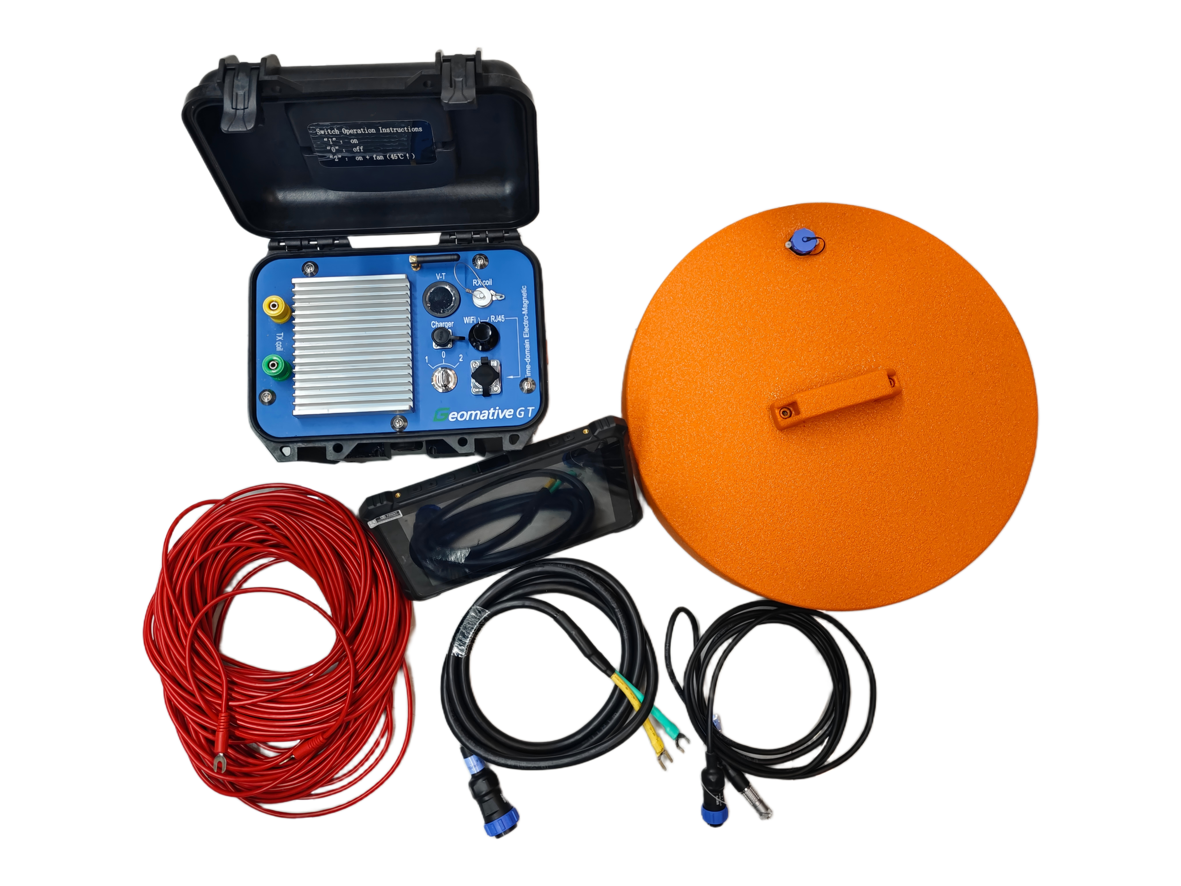
GT-10 Mineral is primarily designed for ground-based mid-to-deep resource exploration, with a detection depth covering 30–600 m. It adopts a cylindrical central probe to replace the conventional overlapped loop, making it smaller, lighter, and more reliable, suitable for both mountainous and flat terrain. The transmitter coil side length can be customized as needed (standard total length 40 m), and a 3×3×3 configuration can be adopted, covering minerals, groundwater, geothermal oil & gas, and coal mine goafs.

Product Overview

Functions:

GT-10 Mineral adopts a large-size transmitting loop and high-current pulses to emit a primary magnetic field into the ground and observe the decaying secondary-field response, enabling high-sensitivity detection of deep low-resistivity ore bodies, fault structures, and geothermal reservoirs. The effective detection depth can reach several hundred meters, suitable for metal mineral exploration, deep geological mapping, and geothermal resource surveys in mid-to-deep exploration scenarios.

Typical Applications:

Mid-to-deep resource exploration (30–600 m, minerals, groundwater, oil & gas); geothermal and oil & gas surveys in high-resistivity overburden areas (carbonate rock, igneous rock, permafrost); environmental and hazard monitoring (water-filled karst, geological structure identification); subaqueous geological engineering surveys for oceans, lakes, etc.; polymetallic ore localization, scale, and reserve evaluation; groundwater exploration, water-filled zones, and electrical stratigraphy; engineering geological surveys (tunnels, subways, underground pipelines, coal mine goafs).

Product Gallery

Ordering Information

GT-10

Application Cases

Mineral Resource Exploration

Mineral Resource Exploration

View more

Core Selling Points

01
Easy and Portable Operation

Receiver + transmitter + power supply all-in-one, 10 kg, 403×330×178 mm, with built-in battery operating for over 8 hours.

02
Direct Coverage of 30–600 m

Output current 150A, max power 3.6 kW, bipolar square wave (duty cycle 1:1), pulse width 10/20/40 ms.

03
Cylindrical Central Probe

Replaces the conventional overlapped-loop setup, smaller in size and lower failure rate, delivering accurate results in both mountainous and flat terrain.

04
On-Site Interpretation Output

Integrated acquisition, processing, forward/inverse modeling, and automatic result output; supports remote data management and real-time upload via wired + wireless dual channels.

Technical Specifications

ParametersGT-10
A/D Converter32Bit
Dynamic Range160dB
Sampling Rate1μs、4μs、16μs、
Number of Channels2
Background Noise1μV
Voltage Measurement Range-200V-200V
Voltage Measurement Resolution≤300nV
Measurement Accuracy0.1%
Input Gain Range1/80-8000
Minimum Sampling Interval4μs
Noise Suppression>100dB
Passband0-500kHz
Stacking Times200
Dimensions403mm×330mm×178mm (L×W×H)
Weight8kg
Operating Temperature-10℃-50℃
Transmit Voltage (V)36-57
Transmit Current (A)25、50、100、200
Current Pulse Width (ms)10、20、40
Transmit WaveformBipolar square wave with 1:1 duty cycle
Max Transmit Power (KW)3.6
Turn-off Time0.5-300μs

Accessories and Attachments

Data Cable

Used for data transmission.

- Spec: Waterproof aviation plug

- Core: Shielded tinned copper wire

Waterproof rating: IP67

Receiver-side Connection Cable

Ordering Information

Material CodeModelNamePlug
M6.0014T-11Surface TEM Probe Connection CableWaterproof Aviation Plug

GT-10 Series Loop and Central Probe

Optional loop coil and central probe for GT-10 Mineral, matched to the exploration depth.

Spec: 6mm²×40m transmitting coil / integrated central probe

Core material: High-conductivity pure copper wire

Protection rating: IP67

Ordering Information

Material CodeProduct ModelProduct NameAppearance MaterialStandard InterfaceApplicable ScenarioApplication End
M4.2002TX-40Transmitting CoilHigh-Conductivity Pure Copper WireBrass Waterproof PlugGT-10 Geological and Mineral ExplorationTransmitting End
M4.2001T-10Integrated Central ProbeEngineering Plastic + Copper CoreWaterproof Aviation PlugGT-10 Geological and Mineral ExplorationReceiving End