


2021-07-20 09:34:42source:
June 8-11, our company will participate in the "4th National Urban Road Subsidence Disaster Prevention Summit Forum and the 3rd Urban Road Underground Disease Body Comprehensive Inspection and Risk Assessment Technology Training Conference" held in Chengdu, and the "2021 China International Urban Pipe Network Exhibition Touring Exhibition - Chengdu Station" and other activities.
At that time, our company will bring the industry's first inertial sensor combined with satellite positioning combined navigation road measurement system - Geopro X100 road intelligent detection platform (hereinafter referred to as "Geopro X100") for exhibition. X100 is compatible with the current mainstream brand of 3D radar, so that the hidden underground cavity disease is nowhere to be seen. With a positioning error of less than 20 centimeters, fully automated data processing, and abnormal batch identification, the Geopro X100 brings a new era of road cavity investigation. Here, we sincerely invite you to come to this exhibition to guide!

The third national urban road collapse disaster prevention and control summit forum site
With China's rapid economic development, ecological civilization construction into a higher stage, provinces and cities are in large-scale urban road disease detection, often thousands or even tens of thousands of kilometers of roads need to be completed in a short period of time, so the construction efficiency put forward very high requirements. The traditional array radar detection program based on GPS/RTK positioning, manual data processing and manual identification of abnormalities not only has low efficiency of road data collection and processing, but also requires professional teams in all aspects, which cannot adapt to the market demand.
Geomative deeply feels the pain point of the market and, adhering to the spirit of innovation, has pioneered the development of Geopro X100 road intelligent detection platform. The industry's first combined positioning system solves the problem of high-precision positioning in urban environments, greatly improving the efficiency of road testing and the accuracy of coordinate information. The Geopro X Workshop enables fully automated data processing for the massive amount of data generated by 3D radar, greatly improving efficiency, while the Geopro Cloud is a cloud platform for collaborative work, submission of field verification data, and delivery of results.
The development of these technologies provides a technical guarantee for us to carry out a large-scale phase of urban road cavity survey and periodic fine detection work, and also provides technical support for the realization of road cavity survey and detection and location of the disease body, and lays a solid foundation for achieving the goal of "early detection, prevention, early warning, quick treatment, and safety" for road collapse disaster prevention and control!

our Geopro X100 road intelligence inspection system and impulse raptor 170M 3D radar for road detection in HangZhou
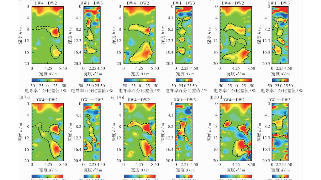
In December 2020, Shanghai Institute of Environmental Science published the article "Research on monitoring of high-density electrical method in the process of in situ remediation of soil", using high-density electrical resistivity imaging (ERT)
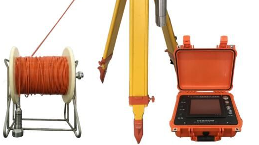
Equipment Configurations:(1) 1 set of GEO-BC BOREHOLE CAMERA main controller(2) 1 piece of probe (φ40mm,φ53mm or φ63mm optional)(3) 1 set of cable winch (0-1500 meters cable,automatic winch)(4) 1 set of tripod(5) 1 set of motor wheel hub and depth counter

Industry-leading geophysical equipment and service provider supplier


