


2023-05-18 12:20:00source:
When all kinds of garbage are buried in the ground, the landfill leachate will gradually infiltrate into the soil from the vadose zone, which will have a certain impact on the soil environment. In view of the significant difference in physical properties between the upper landfill layer and the lower undisturbed soil layer, the precision of high-density electrical method qualitative exploration is limited, and the drilling survey is time-consuming, labor-intensive and costly. The advantages and disadvantages of the two methods complement each other. The spatial distribution characteristics of the buried layer have practical application significance. A landfill site was comprehensively explored mainly by using high-density electrical non-destructive detection and key survey of drilling method, and found out the stratum structure of the site and the spatial distribution of the landfill layer. With the help of Volxer software, the high-density electrical At the same time, GMS software was used to build a three-dimensional landfill solid visualization model, and the application results of the two methods were compared and analyzed, which provided a theoretical basis for landfill pollution control and risk control.
At present, geophysical detection technology, as a non-destructive detection method, is playing an increasingly important role in the process of site pollution investigation. Landfilling of solid waste is one of the effective ways to dispose of industrial hazardous waste and domestic waste. Most of the common landfills are in the open air. After long-term rainfall leaching and vertical infiltration, the landfill leachate may affect the soil. Air belts cause pollution, and are affected by groundwater runoff and pollution migration, which will further pollute the groundwater environment. Therefore, it is of practical significance to accurately detect the spatial distribution characteristics of solid waste landfills for the treatment and restoration of contaminated sites and risk prevention and control. In recent years, many scholars at home and abroad have devoted themselves to the application of geophysical detection technology in the investigation of the site environment. In view of the fact that the detection of the landfill layer by the high-density electrical method is not accurate enough, the characteristics of the site pollution are only preliminarily identified on the surface, and the qualitative accuracy is relatively low. However, when drilling to detect landfills, the field workload, high cost, and time-consuming and labor-intensive shortcomings are not applicable to some landfill site investigations. Therefore, the comprehensive exploration of high-density electrical non-destructive detection and key exploration of drilling methods is studied. The method has guiding significance for obtaining the spatial distribution characteristics of landfills on site.
ERT analysis
Taking an area as an example, the geological structure of this area is relatively simple, with accumulative soil layers on the surface and primary soil layers in the deep, with large differences in resistivity. According to the result map of the high-density profile, it clearly reflects the distribution of resistivity in the survey area.

ERT Resistivity Profile

ERT three-dimensional results
Through on-site RTK data fixed-point measurement, we have drawn a 3D topographic map of the geophysical prospecting area. It can be clearly seen that the survey area presents a topographic trend with low sides and high middle, which is mainly related to the thickness of the landfill.
conclusion
The high-density electrical method was used in this geophysical prospecting work, and a total of 16 ERT survey lines have been completed. The main pollutants on the site are mixed garbage slag containing construction waste, industrial waste, construction waste and industrial waste containing leachate.
Description of landfill distribution:
For this stockpile site, the geophysical prospecting method is used to detect the stockpile area, and corrections are made in combination with the existing drilling data in the previous period. According to the 3D data, it is inferred that about 0~4m from the surface is containing construction waste and slag; about 4~8m is industrial waste; and more than 8 meters is a mixture of construction waste and industrial waste containing leachate.
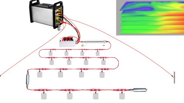
ERT (Electrical Resistivity Tomography) is a technique commonly used in the field of geophysical exploration, which uses resistivity measurement equipment to detect the distribution and properties of underground materials. ERT resistivity instruments can
Recently, the Shenzhen Small and Medium Enterprise Service Bureau announced the list of "Specialized, Specialized and New" SMEs in Shenzhen in 2022. After a series of strict reviews, Geomative won the honors of "Specialized, Specialized and

Industry-leading geophysical equipment and service provider supplier


