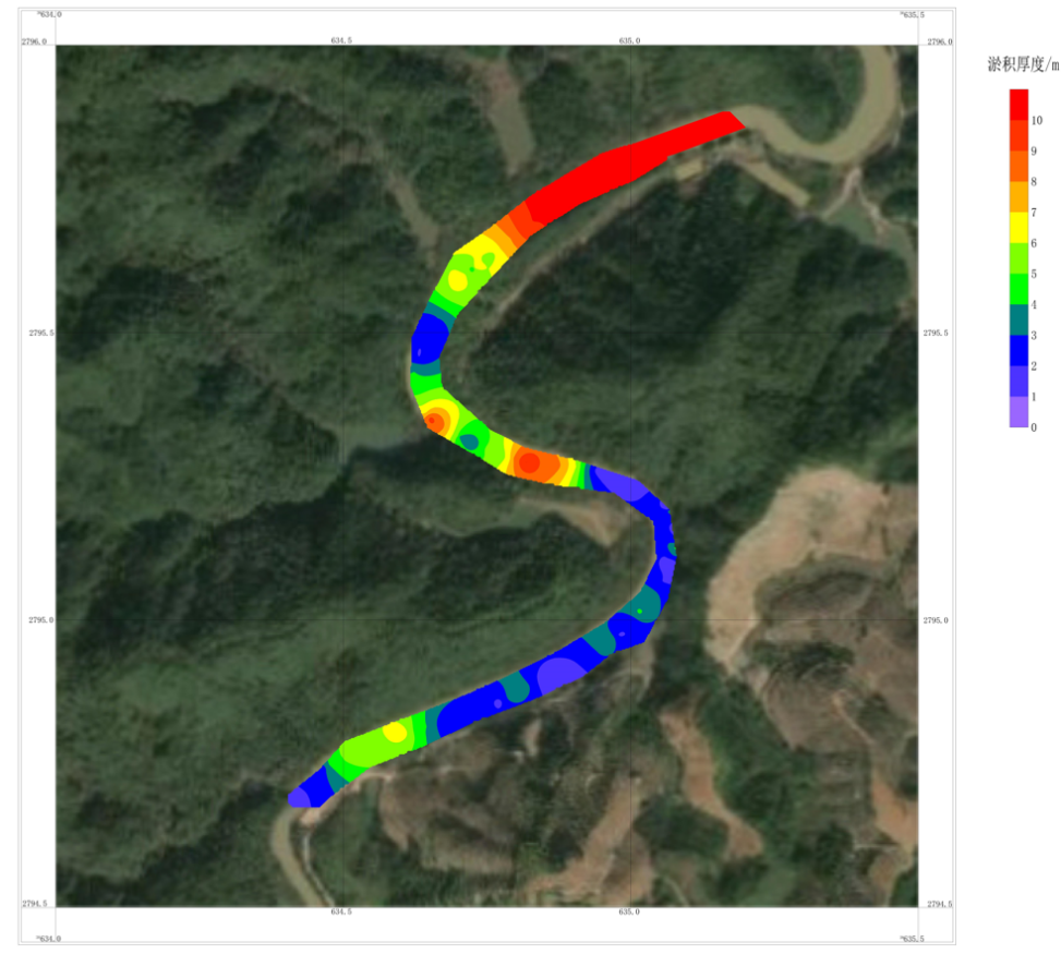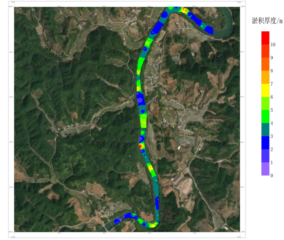
Entrusted to carry out geophysical exploration of a river channel, geophysical exploration high-density resistivity Tomography is used as the main detection method to detect underwater topography and the spatial distribution of silt layers.
The purpose of the high-density electrical survey in the Application of geophysical exploration technology is:
1. Find out the water depth of the river reach in the exploration area, the depth of the bedrock surface, and the thickness and volume of the sediment;
2 Establish a three-dimensional model of sediment space, and evaluate the volume and spatial form of sediment in the yard;

High-density electrometry (Electrical Resistivity Tomography, referred to as ERT detection) is a non-destructive detection technology using a DC power supply, which acquire the potential difference between electrode pairs to analyze the subsurface resistivity structure by bulid up artificial electric field. If it is explained by the simple quadrupole method, that is, four electrodes are inserted on the surface of the earth, two of which are passed through the ground (resistance material) with direct current (as current electrodes) to establish an electric field distribution, and then use the other two electrodes (as potential Electrodes) measure the potential difference between the electrodes, and the resistivity of the underground material between the potential electrodes can be obtained by using Ohm's law, and the resistivity of different formations can be detected through the change of the distance between the current electrode and the potential electrode.
The current and potential electrode configuration and transformation rules used in the field measurement of high-density electrical methods are called electrode arrangement method or electrode array (Array). In fact, the common used array including Wenner Array, Schlumberger Array, Wenner-Schlumberger Array, Gradient Array, Bipolar Pole-Pole Array, Pole-Dipole Array and Dipole-Dipole Array, etc. Due to the difference in the number of electrodes and spatial geometry, correspond to underground structures, the response also has its own advantages, so it is necessary to choose a suitable electrode arrangement method according to the actual situation of different sites.
The continuous dynamic measurement at exploration area by using the Dipole-Dipole (dipole)array , and the static measurement by using the Wenner-Schlumberger (Wenner-Schlumberger) array. The Dipole-Dipole array has the characteristics of deep detection and strong observation signal; the Wenner arrangement array has better resolution for horizontal layered structures and the Schlumberger arrangement array is relatively sensitive to vertical structure detection. The Wenner-Schlumberger hybrid arrangement combines the detection characteristics of the two different array methods have been mixed to obtain a more comprehensive detection arrangement method for horizontal and vertical distribution structures, which is especially suitable for sites with unknown underground conditions or more complex sites, and therefore has better detection capabilities and analytical ability for this water area. Considering that some areas may be shallow in this survey, in order to obtain better resolution and appropriate detection depth, the electrode spacing in this survey is 5m, the minimum isolation factor is 1, the maximum isolation factor is 38, and the maximum power supply Voltage 900V.
The high-density electrical method has the advantages of high resolution, high accuracy and deep detection depth, and is suitable for detecting various stratigraphic distributions and hydrogeological distributions. The processed electrical stratigraphic map can fully present the characteristics of the underground environment.
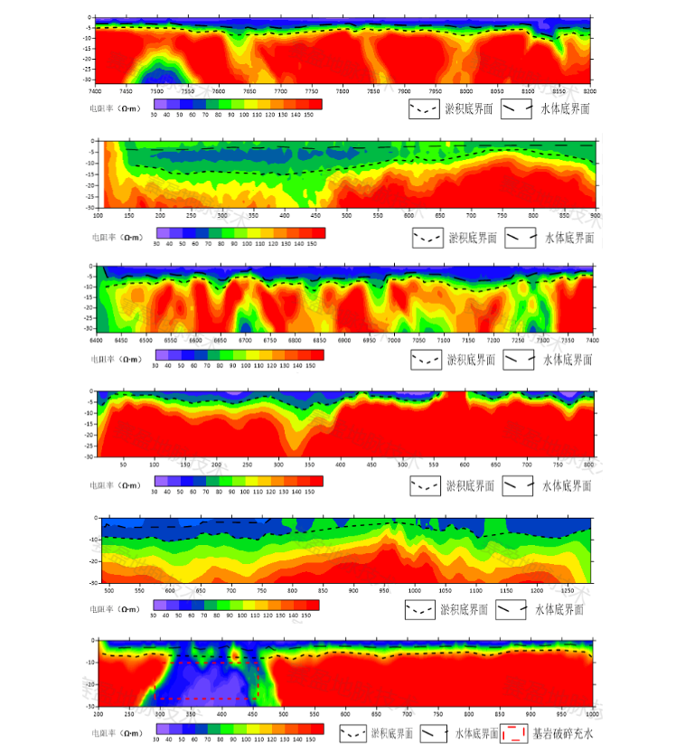
This deep-water dynamic survey uses the Dipole-Dipole array for data acquisition, with 9 survey lines, and the shallow water area is static measurement, using the Wenner-Schlumberger array, with 11 survey lines. The image is intuitive,combined with the regional geological data collected, the analysis is as follows.

A section of deep water dynamic results

Sectional view of static results in a section of shoal

High-density resistivity method results
Through this high-density electrical survey on water, the distribution and depth of siltation in this water area have been roughly identified.