


The XXX factory covers an area of14450m2, mainly engaged in pilot testing of new products, refining of optical brighteners and production of pharmaceutical intermediates and electronic chemical products. In the third quarter of 2018, the factory was demolished as a whole, no production operations were in progress, and the original buildings were all cleared.
Due to the simple production process and relatively weak awareness of environmental protection in the early stage of XXX, the soil and groundwater in and around the original plant in XXX may be polluted by benzene series and chlorinated hydrocarbons to different degrees after decades of production of halogenations and ammoniation.
To this end, XXX factory implemented harmless treatment of ground storage (including construction waste) and remediation of contaminated soil and groundwater in the original factory. As a part of the work plan of the whole supplementary investigation, this environmental geophysical survey program aims to make clear the scope, distribution and pollution degree of soil and groundwater pollution, so as to provide reliable information for the later construction.
Purpose of Investigation and Evaluation
The main purpose of this environmental geophysical investigation is to make clear the pollution situation of benzene series and chlorinated hydrocarbons in the field, and through the analysis of the pollution field, and according to the different physical properties and requirements of the field, establish the electrical model of the potential of pollution Measurement criteria to accurately delineate the depth of soil and groundwater pollution and the spatial distribution of the contaminated area to provide reliable information for later construction.
Scope of Investigation and Evaluation
The scope of the survey and assessment is shown in the Figure 1-2 (before removal) and the blue frame of Figure 1-3 (after removal).

FIG 1-3 Site survey scope(after removal)
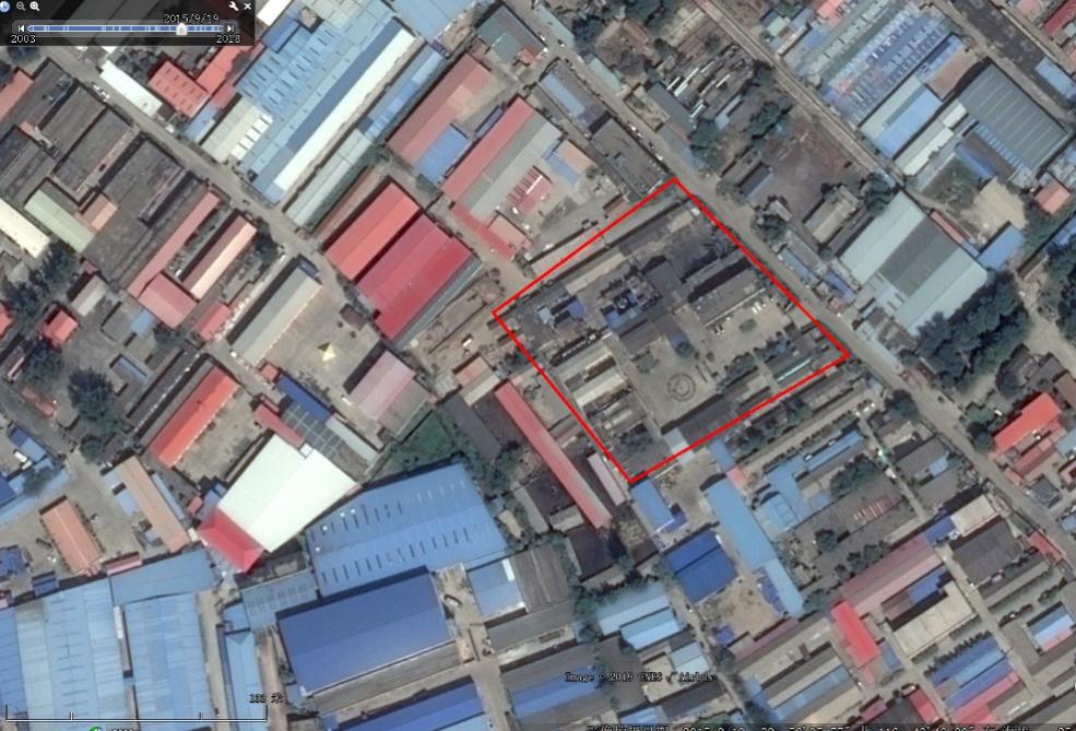

FIG 5-1 diagram of Survey working procedure
The main equipment and instruments to be invested in this project are shown in the following table:
Table 5-1 main equipment and instruments
S/N | Name of Equipment | Specifications | Qty |
1 | GD series high density resistivity meter | GD-20 | 1set |
2 | BP-145 Power supply | GD series | 1set |
4 | BP-450 Power supply | GD series | 1set |
5 | GPS-RTK | SiKouli | 1set |
6 | XRF Luminoscope
| Niton | 1set |
7 | Steel tape | 100m | 2 pcs |
8 | Walkie Talkie | Pioneer | 3sets |
9 | Percussion drilling | / | 2sets |
10 | Water conductivity meter | / | 1set |
11 | Resistivity box | GD series | 1set |
Introduction of main equipments:
GD-20 series high density resistivity meter

FIG 5-2 High density resistivity system
The GD-20 ERT system is a world-leading multifunctional DC resistivity meter independently developed by our company with the latest digital and analog circuit technology. It supports SP/RES/IP function, and can also use for 2D and 3D cross-section profiling. The system can be used not only for traditional ground testing, but also for logging, coal mine tunnels, water surface and underwater testing. In addition, GD-20 can also use online monitoring mode for remote automatic testing to achieve long-term unmanned monitoring.
Gd-20 ERT system contains one mainframe, several switch relay, several cables, several stainless steel electrodes and power supply.
The gd-20 mainframe supports a maximum transmission power of VES is1200V, 6A and maximum transmission power of 2D/3D IP function, the acquisition voltage was increased to ±24V, and the measurement accuracy of current, voltage and polarizability was as high as 0.2% ± 1uA.

FIG 5-3 GD Series Mainframe
2)Accessories of GD-20 Series
CL-20 can effectively protect the inside precision components of the equipment and improve the reliability and service life of the equipment; the cylindrical design of the body and the non-slip matte process of the casing can make the cable head more convenient to use.

FIG 5-4 Switch Relay
CA20 cable has 20 single take-outs with 2m spacing between each take-out.

3)Power supply
BP-450 is the latest generation of digital DC power supply, which can provide 150V, 300V, 450V voltage output. BP450 has current limiting function. When the current exceeds the preset value, it will automatically step down the voltage and limit the current. The current limit is adjustable from 500mA to 1A.
BP-145 is the latest generation of digital DC power supply, which can provide 48V, 96V, 144V voltage output.
The aluminum alloy design of the power supply shell, sturdy, light, and high heat dissipation make it work in harsh environments, and can effectively protect the precision components inside the equipment, improve the reliability and service life of the equipment; LED display screen shows the current voltage Output. The rubber handle enhanced shock protection design, which effectively protects the power supply from accidental shaking and falling during outdoor use.


FIG 5-6 BP-450 FIG 5-7 BP145
4)Percussion drilling

FIG 5-8 Percussion Drilling
(1) Some buildings in the factory area are not demolished, and the ground surface is a cement pavement. During the high-density resistivity survey, the cement pavement will cause high-resistance shielding. Therefore, an electric drill should be used to drill through the cement layer and lay the electrodes during construction.
(2) The main production equipment, ground and overhead pipelines, and ground buildings in some survey areas have been completely dismantled, but it is necessary to determine whether the base structure of the infrastructure has been cleaned. If the base structure still exists, it may cause serious data interference.
(3) Due to factors such as on-site interference, space restrictions, and operational impact, the surrounding environment is more complex and may cause interference to the data.
(4) Due to space constraints, some sites may not be able to expand the ERT line of sufficient length, and the sounding may be limited.
(5) When nondestructive testing technology and geophysical method are used to determine pollution and pipelines, it is inevitable that there will be disputes sometimes due to the existence of multiple solutions to the data. Therefore, comprehensive technical analysis is needed to ensure the accuracy of the measured results. In some cases, the method of core verification can even be adopted.
The main purpose of environmental geophysical methods is to increase on-site information, which extends from the original point of information to 2D and 3D, not to replace traditional detection technology. More on-site information can better verify the accuracy and timeliness of environmental geophysical methods, which is complementary to traditional drilling sampling.
In the factory survey, the density resistivity method can provide the horizontal and vertical distribution at the same time, and present the results graphically to help the owner to grasp the pollution distribution profile of the site. This plan is expected to achieve the following objectives:
(1) Combined with the high-density resistivity method, the information such as the vertical distribution range and depth of soil pollution plumes can be effectively ascertained.
(2) Clarify the stratification and groundwater depth of the site.
Above:https://www.geomative.com/index.php/Geophysical_survey_program_for_the_plant_environment_of_XXX_Chemical_Co_LTD_located_in_XXX/31/69.html


Industry-leading geophysical equipments and service provider supplier


