


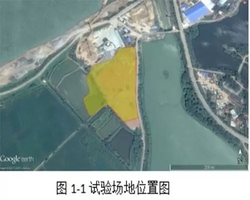
The test area is located in Xiangyin County, Hunan Province. The landfill site is next to the Xiangjiang River. The type of the site is an unlawful dumping landfill with no bottom protection measures. It is adjacent to the surrounding agricultural land and has the problem of exudation of garbage seepage. The types of landfill are mainly living Trash, the geophysical exploration range of about 25,000 square meters, the test area as shown in Figure 1-1 below.
The test area will also measure the ERT(Electrical Resistivity Tomography) resistivity method and induction electromagnetic method ,evaluating the geophysical technology on a large area of waste landfill area and the applicability of the understanding of the underground buried distribution, including evaluation of buried depth, boundary, volume, leachate characteristics and surrounding land formation, providing reliable information for future construction.
geophysical imaging system is often used to mineral detect, underground survey , urban engineer survey and geophysical survey for groundwaterf
The detection project range is about 26000 square meters, and 13 ERT resistivity measurement lines are arranged in the garbage field.
Work planning and deployment
The detection project range is about 26000 square meters, and 13 ERT resistivity measurement lines are arranged in the garbage field.


Method | Length∕area | depth | Array∕Points | Rigid spacing | Spacing | Remark |
EM | 26,000Square meter | 20m | 20,000point | 20~30m | 0.2~0.3m | Fast detection of the distribution range of high conductivity waste water exudation water |
ERT | 100 | 25m | 4PVES、2PVES | 30~40m | 1~2m | Detection of landfill depth, burial volume, and groundwater pollution position |
As the detection results shown that the whole stratum electricity can be roughly divided into four layers from top to bottom, the resistivity show high resistivity (first layer) and low resistivity (second layer), high resistivity (third layers) and high resistivity (fourth layer) electrical change trend, that is the original formation with depth the electrical resistivity trends to rise.o-fareast

The first layer of evaluation for dry garbage and soil, has the characteristic of high resistivity, a depth of about 0 to 2.5 meters, the range of resistivity is about 15 ~ 60 Ohm-m, the resistivity falls on the green to red and yellow color, analysis of average depth of about 0 to 2.5 meters.

Second layer composite evaluation for wet resistivity living garbage and landfill leachate, because it contains a lot of leachate, has obvious characteristics of low resistivity value, the resistivity value range is about 100 ~ 150 Ohm-m, the resistivity levels fall in blue interval,the average depth is about 2.5 ~ 12 meters.

Third layer composite evaluation for the living garbage and wet background formation at the junction of composite resistivity, has obvious characteristics of low resistivity, the resistivity analysis range is about 10 ~ 20 Ohm-m, the resistivity levels fall in green interval, analysis of average depth of about 8 to 18 meters


3D ERT resistivity method Interpreted
The landfill electrical resistivity tomography to E-1 field E-13 line results establish the 3D model, test instrument can be used for 3d resistivity imaging it can obtain all the field data results. As shown, the overall analysis of 0 ~ 15 meters most are low resistivity, resistivity less than 20 Ohm-m, through the 3D depth section shows a depth of 15 meters, the formation resistivity have been rising feature analysis, has been close to the original formation, suggesting that 3D section depth of 18 ~ 20 meters for the original formation, no landfill resistivity. The distribution of 3D resistivity below 15~20 Ohm-m is analyzed. The average buried depth is 11.5 m to 13.5 M. the volume of garbage is about 300 thousand to 350 thousand M3.o


Industry-leading geophysical equipments and service provider supplier


